UK: Losing One's Self in the Mendip Hills, Somerset County
- oldbagonaplane
- Oct 2, 2021
- 8 min read

Updated: Jun 25, 2022
Holiday in the UK: My recent mini-staycation in Somerset County gave me the opportunity to tour Glastonbury and Glastonbury Abbey, Glastonbury Tor, and the town of Wells. I combined these tours with a walking holiday of the Mendip Hills and Ebbor Gorge.

There are many etiquette rules for driving on a single track road. A single-track road is a road that permits two-way traffic, with room only for one car at a time. The driver closest to the passing place should reverse and pull over. One should always concede to the car moving uphill. Always smile and wave when passing. Flash your headlights to encourage the other driver to move, but try not to blind them at the same time. There is a word for city folk who don't understand single-track etiquette, but I don't remember it is. As a city folk, I must have blocked it out.
The first time I encountered the tactical challenges of sole-artery car travel was also the first time I drove on the left side of the road. In 1998, we went on holiday to Ireland, driving along the south coast and staying in a different castle each night. The castles were magical, but driving the single-track roads of the Irish countryside left a few emotional scars. Traffic on these roads was a mixture of local drivers in compact cars going at high speeds, and 18-wheel trucks, also going at high speeds. My abilities were best summarised by my husband, who explained that leaning to the left while inside the car to avoid an oncoming car was not going to save me from a head-on collision. I lived in fear of on-coming traffic.
The less said about this driving experience, the better. I should never plan road trips. But here I was again, 23 years later, in a car, on a single-track road crying my way through the single-track lanes of the Mendip Hills. I'm still leaning to the left.
Located in Somerset County, the Mendip Hills offer visitors almost too much to see and do. This National Trust parkland encompasses ancient woodlands, dramatic gorges and pristine coastlines. I planned to combine my Goddess-site Glastonbury trip with some hiking.
Look on most 'Top Ten Things to do Near Glastonbury', and Cheddar Gorge will be close to the top. It is for that exact reason I went to Ebbor Gorge instead.
Cheddar Gorge is Britain's largest gorge. The cliffs rise 450 ft and are three miles long. This is an Area of Outstanding Beauty with a signposted walking path. Cheddar Gorge is very popular with families and walkers, so the paths can get quite busy.

The name Cheddar Gorge has less to do with cheese and more to do with the word Old English word, CEODOR, which means dark cavity or pouch. This was the town's name, and if the town resembled a dark cavity or pouch, it must not have been a great place to live. Even if cheddar cheese, named after the town, was created here. So, the town came before the cheese, and the gorge, which was there long before both, does not resemble the cheese.


Saying that, the Cheddar Gorge Cheese Company still matures cheddar in Gough's Cave. The vintage cow's milk cheese is .01% lactose, and an excellent choice for those who usually don't get along digestively with dairy!

There are a series of stalactite caverns under the gorge, including Gough's Cave. In 1890, archeologists found a complete skeleton inside Gough's Cave, and named him 'Cheddar Man'.
Ched is over 10,000 years old and is the oldest near-complete skeleton ever found. He is said to have had lovely blue eyes and met with a violent death.
About a mile from the cave is another cave site called Aveline's hole. This is the burial site of over 50 mesolithic people. The Cheddar Yeo, Britain's largest underground water river system, flows freely through the caverns of Cheddar Gorge.
Ebbor Gorge is known as the 'Mini-Cheddar' or a Babybel if you like. It is set within the ancient limestone of the Mendip Hills, and is a National Nature Reserve. Here you’ll find woodland, rocks and caves. There are small streams for paddling and lots of wildlife spotting.

The Ebbor Gorge Circular is a 4.7 kilometre moderate loop trail. Moderate has my name all over it, so it was to this trail that I headed. If I were a dedicated rambler, I could have chosen a 2.8 mile route walking from Wells, where I was staying, through Wookey Hole. But this was before the petrol tanker driver shortage, and why walk when I can drive? An online review guide suggested I park at St. Mary Magdalene's Church on Wookey Hole High Street, with directions from there. I set off that morning thinking it could not be easier.
Park outside the church. With the church on your right, walk along the High Street until you reach an arched stone bridge over a stream on your left, Stop here alongside a group of buildings.-online review guide.
I found none of these things. Failing to find the church, or even Wookey Hole High Street. I consulted another guidebook, which suggested parking at the Ebbor Gorge car park. I set my GPS for that location, and this is where all my trouble started.
From the A371, I turned Titslands Lane and then to Kennel Batch. The road began to get slimmer, and slimmer but still manageable. Then came the fork in the road and the GPS was incapable of determining which way to go. I knew that if I chose the wrong direction, as I am wont to do, I would not be able to turn around on the single-track road.

I selected the wider road, sensibly named Ebbor Lane, instead of Deerleap Lane, which looked more ominous. Ebbor Lane, of course, took me down a very narrow single-track lane, eventually finding a small residential area, but no gorge car park.
I turned around three times, then followed Ebbor Lane back from where I came. Swallowing hard, I turned up Deerleap Lane, followed the even tighter roads, then eventually found the Ebbor Gorge Car Park.
There is a map sign in the car park, so I double-checked my walking route, and turned left, exactly in the opposite direction and off the demarcated walking route. I found myself on a public footpath, then I found myself in some farmland...again. Some time ago, I had downloaded the OSMaps app that lovely Antonia told me would get me out of any hiking jam. She explained it was straightforward to use and there was no way I could get lost. I stood in the woods for a good 30 minutes trying to turn it on and finally realized that you must, in fact, plan your walking route before you are on it. Otherwise, when you are lost, how do you know where you are to start the map, or where you are going as your final destination. I put my phone in my pocket and continued on, instinctively, which is usually a mistake.

I heard voices behind me as I went through the first of two consecutive kissing gates. A kissing gate is a gate that you must get into to get out of. They allow pedestrians to pass through, but not livestock.
The couple passed through the first gate, but as I stood in a field, once again trying to get the OSMap to locate me, I did not hear them pass through the second. I turned to find they had chosen a different path, one going south, the path I had expected to be on.
I followed, giving them enough distance to not cramp their style. This was difficult because I wanted out of these woods very badly, and they kept stopping to train their dog with commands like, 'over this log', 'don't kill the squirrel', and 'sit, while I catch my breath!'.
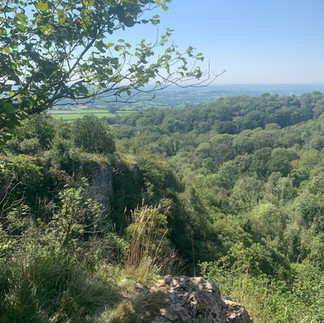
Before long we had reached sign posts noting the Circular Path and I didn't need them any more. The path then opened on a rocky expanse that is the viewing area for the Ebbor Gorge. From here you can take in the spectacular vistas of the Mendip Hills, the limestone cliffs, and the ravine of the gorge.


Soon, rested and hydrated, I was back on the Circular Path and heading toward the car park. It was so much easier this way! No farmland, no kissing gates! The path through this peaceful and ancient forest is scattered with dog's mercury, wood anemone, and common bluebells. The scariest thing in this forest is a wicker bear with hydrangea boobs.

Though failing in attempts to navigate myself with the OSMaps app, I did feel a sense of accomplishment. I got myself out of the forest, was not attacked by a cow, and did not heave myself off the edge of the gorge out of frustration at not being able to read a map.
I drove out of the car park and into the single-track road with a sense of confidence I hadn't felt since before setting out on the road that morning. Not only that though, I even, though I had the right of way, reversed about a half-mile without hitting the sides of the road to let another car pass. Confidence allows for courtesy every so often!

It wasn't until after my disorientating dalliance in the Mendip Hills that I learned of the curse of the Mendip Serpent. Jokes, there isn't a basilisk malediction, but the Mendip Hills are great breeding grounds for adders. The rocks of the Mendips are perfect for them, with limestone scree piles that create chambers comfortable for hibernation.
The venom of an adder snake is only dangerous if there is an allergic reaction, but you should still seek medical attention. The venom is, however, it is dangerous to dogs.
As I said, there are almost too many things to explore in Somerset County and the Mendip Hills.
Dolebury Warren is an Iron Age fort from 3000 years ago. It is now a nature reserve with grassy ramparts that attract rare butterflies. There are some walking trails and grazing animals.
Tor Hill Woods is an ancient woodland not far from the city of Wells. There are many paths through the woods that offer beautiful views of Wells Cathedral.
Crook Peak is one of the largest areas of open land on the Mendips. It rises 191m and has breathtaking views over Somerset. Along the limestone ridge from Crook Peak is Shute Shelve Hill. There is a Saxon boundary bank and ditch here, and it is very popular with hikers, walkers, and horse riders.
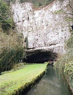
The Wookey Hole Caves on the edge of the Mendip Hills is a series of limestone caverns where human habitation dates back over 45,000 years. The River Axe flows through these caves and were the site of the first cave dives in Britain in the 1930s. There are approximately 25 chambers meandering about 13,000 feet. The caves are a popular tourist attraction and were once owned by Madame Tussauds. The cave is notable for the Witch of Wookey Hole, a human-shaped stalagmite that legend says is a witch turned to stone by a monk from Glastonbury.


The cave temperature is a constant 11c/45F degrees and is perfect for storing cheddar cheese. I've now discovered three cheese caves in the UK, and I am, as cheese-storing caves seem to be common occurrences, wondering if they are deserving of more exploration. My sister and I once reconnoitered underground slate shafts in Llechwedd, Wales. There was no channeling Eleanor Roosevelt's depression-era coal mine tours, as I had hoped, and she has to recover her trust in my travel planning skills.
#EbborGorge #SomersetCounty #UK #England #EnglandTourism #UKTourism #UKStaycation #HikingUK #WookeyHole #WellsUK #CrookPeak #TorHillWoods #Glastonbury #CheddarGorge #GoughsCave #CheddarMan


Comments